combinedLogos.png  
Other links: WASA Online Graphs   WASA FAQ   Wind Atlas for South Africa (WASA).kmz
WASA1:    Arrangement Drawing   Instrumentation Summary   Mast Site Information   Station and Site Description Report (April 2014).pdf
WASA2:    Arrangement Drawing   Instrumentation Summary   Mast Site Information   Station and Site Description Report (April 2017).pdf
WASA3:    Arrangement Drawing   Instrumentation Summary   Mast Site Information   Station and Site Description Report (Dec2019) v1.pdf
Welcome to the WASA download site, Niels G

You are logged in as nimo@risoe.dtu.dk

WASA1 Final Reports (April 2014)
WASA2 Final Reports (December 2018)
WASA3 Final Reports (March 2021) UPDATED (2021/06/15)

WASA1 Wind time series downloads

WASA1 Extreme wind atlas downloads
WASA2 Extreme wind atlas downloads

WASA1 Large Scale Wind Resource Map (April 2014)
     - an update of and replacement of WASA1 Interim Large Scale Wind Resource Map (May 2013)

WASA2 High-Resolution Wind Resource Map (December 2018)
     - an update of and replacement of WASA2 Interim High-Resolution Wind Resource Map (October 2017)

WASA High-Resolution Wind Resource Map (March 2021) UPDATED (2021/10/01)

WASA Wind Atlas downloads

WASA Meteorological data downloads
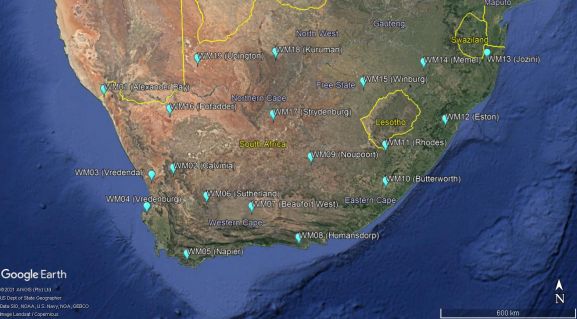
Please choose the sites from which you wish to download data.
WM01 (28°36'06.7"S, 16°39'51.9"E - since 2010-06-23)
WM02 (31°31'29.7"S, 19°21'38.7"E - since 2010-06-30)
WM03 (31°43'49.4"S, 18°25'10.1"E - since 2010-06-24)
WM04 (32°50'41.2"S, 18°06'34.5"E - since 2010-05-18)
WM05 (34°36'41.6"S, 19°41'30.3"E - since 2010-05-20)
WM06 (32°33'24.4"S, 20°41'28.7"E - since 2010-09-17)
WM07 (32°58'00.2"S, 22°33'23.8"E - since 2010-05-28)
WM08 (34°06'32.0"S, 24°30'49.0"E - since 2010-08-04)
WM09 (31°15'05.8"S, 25°01'50.2"E - since 2010-09-01)
WM10 (32°05'26.5"S, 28°08'09.0"E - since 2010-08-05)
WM11 (30°48'51.6"S, 28°04'25.3"E - since 2015-10-27)
WM12 (29°51'00.4"S, 30°31'42.8"E - since 2015-10-16)
WM13 (27°25'34.2"S, 32°09'58.1"E - since 2015-10-15)
WM14 (27°52'54.1"S, 29°32'36.4"E - since 2015-10-02)
WM15 (28°37'11.9"S, 27°07'23.4"E - since 2015-09-30)
WM16 (29°26'39.2"S, 19°21'25.1"E - since 2018-10-25)
WM17 (29°45'29.1"S, 23°31'12.6"E - since 2018-11-09)
WM18 (27°35'50.5"S, 23°39'19.4"E - since 2018-11-08)
WM19 (27°43'36.1"S, 20°34'06.0"E - since 2018-10-24)
WASAMap2.jpg

Website Disclaimer
By using this website, you agree that the exclusions and limitations of liability set out in this website disclaimer are reasonable. If you do not think they are reasonable, you must not use this website.

The information contained in this website is for general information purposes only and provided 'as is'. Whilst we endeavour to keep the information up-to-date and correct, we make no representation or warranties of any kind, express or implied about the suitability, completeness, accuracy of the information and/or the availability at all of the website. In no event will we be liable for any loss or damage including without limitation, direct, indirect, special or consequential loss or damage, or any loss or damage or for any business losses, loss of revenue, income, profits or anticipated savings, loss of contracts or business relationships, loss of reputation or goodwill, or loss or corruption of information or data arising out of or in connection with the use of this information. Any reliance you place on this information is therefore strictly at your own risk. Nothing on this website constitutes, or is meant to constitute, advice of any kind. If any provision of this website disclaimer is, or is found to be, unenforceable under applicable law, that will not affect the enforceability of the other provisions of this website disclaimer.

CSIR - Copyright 2010 © All Rights Reserved - Updated: June 2010
Webmaster